Ethnicity Guesser vs GeoGuessr: A Coordinate or a Citation
GeoGuessr and this site both end a round by naming a place, yet only one of the two has a measuring instrument behind the answer. One answer is a coordinate logged at capture; the other is a citation list.
The same gesture, two different answers
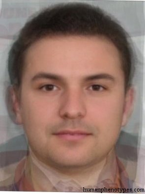
Both games begin with a stimulus and end with a place. In the first you are dropped into a street panorama and asked where on Earth you are standing. In the second you are shown an averaged face and asked which documented regional pattern it most resembles. The gesture is identical: read the evidence, then name a location on a map. What separates them is not the interface but the object being named, because underneath that pin sits either a coordinate recorded when the picture was taken or a list of printed sources compiled by named authors in named decades.
Geography quizzes train players to expect an answer key, and once you know the answer is a place on a map you can argue about precision, measure your error and try to shrink it next round. That expectation is what makes a comparison between these two products worth taking apart. They share a shape, stimulus then pin then verdict, and share almost nothing about how they know what they know. One inherits a surveyor's habit of measuring. The other inherits a library, and a library answers a different kind of question, one that arrives with a shelf mark rather than a decimal.
One answer is a coordinate
GeoGuessr, a street-imagery location quiz released in 2013 by the Swedish developer Anton Wallen, drops a player into a Street View panorama and scores the distance from the dropped pin to the place where the imagery was captured. That last word carries the weight. Street View vehicles log position at the moment of capture, so the answer is not a judgment about a location; it is a number attached to a file. A round tops out at 5,000 points and a standard game runs five rounds, which produces the familiar 25,000-point ceiling. Near-perfect rounds are routine for strong players precisely because the target is unambiguous: a point in a coordinate system, written by an instrument, retrievable on demand.
The scoring curve is instructive even though it is not published. That absence sounds like a gap until you notice what it implies: when the target is a distance, anyone with a spreadsheet can reconstruct a function that fits the observed points. One published attempt, in a 2024 computer-vision paper that describes a bot trained to play the game, recorded in-game results and fitted a single exponential whose decay constant sits near 1,493 kilometres. Community measurements built on a map's bounding-box diagonal reach the same shape with different constants. Independent fits agree on the structure because there is a real quantity underneath them. Reverse-engineering a ruler only works when something is genuinely being measured.
The other answer is a citation
The catalogue this site publishes has no instrument behind it. Take Choshiu, recorded along the west coast of Honshu and named after the old Japanese Choshu domain. Its entry credits the name to Baelz in 1883, notes that Eickstedt retained it in 1952, and lists Saller in 1949, Weinert in 1965 and Vallois in 1971 among later users. Volgid, documented in the basins of the Sura and Moksha rivers, was named and defined by Lundman in 1967, who also called it Wjatkid, while Bunak had described the same complex in 1932 as Sub-Uralic. West Alpinid was called Keltoid by Broca in 1868 and renamed by Gros and Lapouge in 1897, then carried forward by Deniker, Coon, Eickstedt, Biasutti and Knussmann.
Neo Melanesid shows how the argument works in practice. Eickstedt named it in 1934, Biasutti preferred Papuasid in 1941 and again in 1952, Vallois and Debets wrote Papuan, and Lundman treated Papuid as a mixture of three other types. The pattern is the same object; the labels multiply. So the answer to a round is a bibliography rather than a point, and the entries are not equally supported. Choshiu lists eight sources and Neo Melanesid ten, while Volgid lists five. A coordinate can be wrong by forty kilometres and you can say so. A named type can only be contested the way an interpretation is contested: the observation may be thin, the sample uneven, the naming disputed.
Both maps carry a date stamp
Neither answer is timeless. Street View imagery is dated at capture and replaced unevenly, so a panorama can show a junction rebuilt ten years ago, a shopfront that has since closed, or a road photographed before a bypass took the traffic. The catalogue's clock runs in the other direction. Its printed sources were written between 1825 and 2014, and the distributions are anchored to roughly 1500 years ago, which puts the reference on a map assembled before many of the states a modern quiz would name. West Alpinid's citation list spans a hundred and twenty-eight years. Choshiu's spans sixty-two. Every entry is dated twice, by the fieldwork and by the baseline.
Modern movement makes the second date matter more. Populations have shifted, cities have absorbed their hinterlands, and the share of people living where their grandparents lived has fallen across most of the world. A round can therefore be placed with perfect precision and still show a photograph of a place whose population has changed far beyond the sample that was measured. That is the complication both games carry, and the catalogue states it in its own pages: an entry describes a statistical tendency in a historical sample, not a group of living people and not a nationality. A player who reads the date stamp is playing a game about a map. A player who skips it is quietly asserting something about people who never sat for the measurement.
Where GeoGuessr is the stronger tool
Fairness requires saying this plainly. If the goal is a hard, repeatable, rankable challenge, GeoGuessr is the more complete product. Its imagery comes from the largest street-level fleet in the world and reaches places volunteer projects rarely photograph. Its competitive layer runs deeper than anything built on a fixed catalogue: timed duels, elimination formats, and a shared daily map that lets thousands of players attempt identical rounds under the same clock. Its scoring curve has been tuned over years by a company whose business depends on that curve feeling fair. None of that is incidental, and none of it is matched here. A reader who wants to be ranked against strangers has found the right product.
Neo Melanesid and Volgid cannot compete on that axis, and they are not trying to. What they offer is inspectability. Open either entry and you can see the name, the region, the author who coined it, the year, and the printed works it was drawn from. Where the street-imagery game asks a player to trust a curve that no page explains, the catalogue asks the reader to open the shelf. That is a narrower appeal: fewer players, slower rounds, no leaderboard worth climbing. It is also the only one of the two where a curious reader can follow a claim back to a specific printed page and decide for themselves whether the description holds up.
Which question you actually have
The productive move is to work out which question you are asking. If you want a fast, testable, socially comparable skill with a score, a rank, and a curve to improve against, the street-imagery game is the right instrument and the catalogue is a poor substitute for it. If you want to understand how later observers described visible variation and where they placed it, a scored pin tells you nothing while a sourced entry tells you a great deal. The catalogue is not a harder version of a geography quiz. It is a different genre that happens to share a pin-drop interface and a world map.
Neither product answers the question most people arrive with. A resemblance claim can be wrong and can be revised when a better sample appears, and that is the only kind of claim this catalogue makes. Where was this person photographed, and what are they, are questions that neither game can settle, because one is about a camera position and the other is about a body of literature, and neither is about a living person's identity. Read that way, the comparison ends where it should: two tools, two kinds of ground truth, two audiences. Choose the one whose answer you actually wanted, and know which of the two you received.
Frequently Asked Questions
- Does GeoGuessr use the same kind of answer as the face quiz?
- No. A GeoGuessr round ends at a coordinate logged by the camera that captured the panorama, so the answer is a recorded quantity and the error can be measured in kilometres. A catalogue round ends at a documented pattern named after a landform or region and sourced to printed works. Both involve dropping a pin, and only one of them has an answer that an instrument wrote down.
- Why does the catalogue name types after rivers and mountains?
- Because the catalogue is a historical record rather than a political one. Choshiu takes its name from an old Japanese domain, Volgid from the Volga basin where it was documented, West Alpinid from the Western Alps, and Neo Melanesid from Melanesia. A landform outlives the administrations sitting on it, so an entry stays readable across redrawn borders. Naming by country would have dated every entry within a generation.
- Can a face quiz ever be scored as precisely as a map quiz?
- Not in the same units. A distance is a physical quantity with a known relationship to the score, which is why the player community could reconstruct the game's curve from recorded results. A resemblance verdict has no units, only agreement with a description. Precision in the face game means a tighter reference sample and a clearer statement of which features were compared, and the result is a range rather than a single number.
Related Phenotypes
Faces from the encyclopedia that appear in this article. Open any entry for its full description, distribution, and references.
West Alpinid
Central Europe
Alpinid proper, historically found in the mountain regions of Western Europe. Often a cohabitant of a second mountain type, the Dinarid. The...
Choshiu
East Asia
Gracilised variant of the Manchu-Korean type, named after the old Japanese Choshu Domain. Once common in Chinese-Korean aristocracy. Today m...
Volgid
Eastern Europe
Eurasian type, especially common west of the Ural in the basins of Sura and Moksha Rivers of Russia. Found in Mari, Chuvash, Volga-Finns. Mo...
Neo Melanesid
Melanesia
Melanesid subtype of New Guinea. Found especially in lowlands and river plains, with its highest concentration in the south of the island. M...
Test what you learned
Put your eye for regional faces to work in the daily quiz — a composite face, a world map, and your best guess.