Ethnicity Guesser vs GeoGuessr: Clues the Camera Left Behind
Both games end with a pin dropped on a map, but only one rewards a player who reads the equipment that took the photograph before answering.
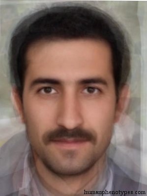
Two ways to look at a picture
A standard round in GeoGuessr hands the player a panorama and a set of controls. You can rotate the view, zoom until a road sign resolves into letters, and in the common moving format travel a few hundred metres looking for a town name. A competitive setting strips all of that away, and the game's own abbreviation for it is NMPZ: no moving, no panning, no zooming. The opening frame becomes the entire round, and whatever the camera happened to face is the whole evidence base.
The face branch of this site runs the second kind of round by design. One composite image appears, nothing rotates, and there is no sign to zoom into, because a synthetic average contains no signage, no vehicles and no weather. Call the difference search against lookup. A panorama can be interrogated until it gives something up. A composite can only be recognised, and every question a player might want to ask it has already been settled by whoever built it.
What the camera leaves in the frame
Much of a strong player's edge in the street game comes from marks nobody meant to publish. Community guides describe the earliest coverage, generation one, as confined to the United States, Australia and New Zealand, and the second generation as carrying a purple-tinted patch at the bottom of the frame where the rig meets the car. One example circulates often: the vehicle that photographed Ghana wore a roof rack with black tape along one end. None of that is a fact about Ghana.
The marks exist because the imagery is manufactured. A fleet of vehicles, each with a mounting, a lens and a compression setting, drives a road and records it, and the recording keeps the fleet's fingerprints whether or not anyone wanted them there. Photographs made by a different team in a different year differ in ways that have nothing to do with the country in front of the lens. That is why the meta can be taught at all: it is a signature, and signatures repeat.
A composite signs its own frame too
Average a stack of aligned portraits and the arithmetic leaves marks of its own. Independent variation between photographs falls with the square root of how many were combined, so texture flattens as the stack grows and features that never quite line up smear at their edges. Pose is fixed by whatever alignment step was used, the light is whatever the source photographs shared, and no expression survives the process. A composite announces itself the way a nadir does, and for the same reason.
What differs is how much the signature can carry. A purple nadir narrows a round to a band of years and, through those years, to a shortlist of countries. A smooth cheek says only that many photographs were stacked. Nothing in the smoothing points east or west, because the averaging step has no geography inside it. The composite's fingerprint is therefore a single bit, synthetic or not, and a player who reads it has learned about a pipeline rather than a place.
Four names, four conventions
Open four entries side by side and the naming conventions stop resembling coordinates. Iranid takes its name from a plateau, and its record runs the pattern from southwestern Iran into Afghanistan and India, which is roughly what a plateau does. Malabarese is named for a coast and the people living on it, described from Kerala. East Palaungid borrows the name of a Mon-Khmer speaking people in Myanmar while placing the pattern in the hills of South China, from Yunnan through Guizhou and Sichuan. Trans Mediterranid, defined by Eickstedt in 1934, is named for a direction and located in North Africa.
Each label answers a slightly different question: where a landform sits, who was measured, which way a population is thought to have moved. None of them is a point. A street-game answer can be checked by measuring a distance, and being wrong by forty kilometres is a fact anyone can verify with a ruler on a screen. A name can only be checked by opening the shelf and reading who coined it, who kept it and who quietly dropped it, which is a slower and more argumentative procedure.
Feedback comes in two shapes
A street round returns a number that falls smoothly as the pin drifts. Scores run to five thousand per round and decay with distance, so a guess two hundred kilometres out and a guess two thousand kilometres out arrive as different numbers rather than as the same verdict. That gradient is the teaching mechanism. A player who keeps landing a factor of ten too far west in one region can see the bias in their own score history and correct it next round.
A catalogue comparison returns a label, and labels do not grade. If a composite sits between two entries, the answer is one of the two, delivered with the same confidence as an exact hit. There is no partial credit and no distance, so a near miss and a wild guess look identical from outside. Practising under that feedback builds fluency with a vocabulary of 209 entries. It cannot build precision, because nothing in the response measures how far the judgment travelled.
What carries over, and what the map did next
Two habits transfer between the games, and neither is the pin. The first is building a regional prior before committing to an answer: a street player who recognises a road surface and a signage family is performing the same operation as a reader who narrows a described pattern to a plateau. The second is stating a confidence band instead of a verdict. What does not transfer is precision, since one game grades a distance and the other has no unit to grade with.
Both are archives of a moment that has passed. Street imagery is stamped with a capture date and replaced unevenly, so a round can be played on a photograph of a junction rebuilt since. The catalogue's apparatus is a printing press rather than a camera: its 1,367 dated references have a median year of 1956, and only 34 of the 209 entries cite anything printed before 1900. A pattern measured in that decade describes a distribution as it stood then, before the migrations and the urban growth that reshuffled where people live. A correct answer is a claim about a sample.
Playing each without confusing them
The practical split is simple. In the street game, learn the fleet: which generation a frame belongs to, what the mount leaves at the bottom edge, which infrastructure belongs to which country. In the catalogue, learn the naming: whether an entry is named for a landform, a people, a direction or a person. The two vocabularies look alike on a page and reward opposite habits, which is why a player who is excellent at one can be confidently wrong at the other.
- Treat a nadir, a plate shape or a stitching seam as a fact about the camera, never about the country.
- Treat a catalogue name as a naming act with an author and a date attached to it.
- Ask which year you are playing: the imagery's capture date, or the printed baseline of the sample.
- Score yourself on distance in the street game, and on whether the cited source actually supports the claim in the other.
- Stop at the point where a label would turn into a statement about a living person.
Frequently Asked Questions
- Is ethnicity guesser the same kind of game as GeoGuessr?
- They share a shape, not a method. Both show a picture and ask for a place on a map, and both return a verdict from a fixed answer space. The street game's answer is a coordinate logged by a camera, so it can be graded as a distance. A composite-face game's answer is a named pattern from a published catalogue, graded against an entry rather than a point. One rewards reading equipment, the other rewards knowing a bibliography, and a player trained on either will find the other's habits close to useless.
- Why do GeoGuessr players care about camera generations?
- Because the imagery was made by a fleet, and each generation of equipment leaves different marks. Community guides divide coverage into generations and note that the earliest appears only in a handful of countries, while later equipment produces sharper frames with different colour handling. A frame's quality and its artifacts therefore narrow the map before any landscape is read. It is metadata that survived publication, not a geographic clue, which is exactly why it works so reliably in a game built on borrowed photographs.
- Does a composite face contain clues the way a street photo does?
- It contains one, and it is a weak one. Averaging many aligned portraits reduces random variation, so the result is smooth, expressionless and evenly lit, and the edges of features blur where the sources disagreed. Those properties identify an image as synthetic. They say nothing about where the sources came from, because the averaging step has no geography in it. A street photo, by contrast, is dense with unintended information: number plates, pole design, road paint, the shadow of the vehicle carrying the camera.
Related Phenotypes
Faces from the encyclopedia that appear in this article. Open any entry for its full description, distribution, and references.
Iranid
Middle East
Distinctive type of the Iranian Plateau. One of the main elements in Persians, especially in Southwestern Iran. An important element in Kurd...
Malabarese
South Asia
Indid-Veddid influenced type of Southwestern India, found in its most typical form in Kerala, e.g. in Malabarese and related people. Common ...
East Palaungid
Southeast Asia
Eastern Palaungid variety, found in the hills of South China. Shows stronger Sinoid tendencies. Common along the China-Myanmar /-Vietnam bor...
Trans Mediterranid
North Africa
Widespread Mediterranid subtype with many morphological features intermediate between Eurafricanid and Gracile Mediterranid. Possibly a grac...
Test what you learned
Put your eye for regional faces to work in the daily quiz — a composite face, a world map, and your best guess.